
HISTORIC MAPS OF SALEM
Salem Maps - Leventhal Map Center, Boston Public Library
The Norman B. Leventhal Map & Education Center at the Boston Public Library, created in 2004, is a nonprofit organization established as a public-private partnership between the Library and philanthropist Norman Leventhal. Its mission is to use the collection of 200,000 maps and 5,000 atlases for the enjoyment and education of all through exhibitions, educational programs, and a website that includes more than 10,000 digitized maps at collections.leventhalmap.org. The map collection is global in scope, dating from the 15th century to the present, with a particular strength in maps and atlases from the New England region, American Revolutionary War period, nautical charts, and world urban centers.
Click on all maps for further detailed information

Plan of Salem Common, 1800 by Anonymous c/o Boston Public Library’s Leventhal Map Center

Chart of the Harbors of Salem, Marblehead, Beverly, and Manchester, 1806, by Nathaniel Bowditch. c/o Boston Public Library’s Leventhal Map Center

Plan of Salem, 1820 by Jonathan Peele Saunders. Digital copy c/o Boston Public Library’s Leventhal Map Center

Map of the City of Salem, 1851, by Henry McIntyre. c/o Boston Public Library.Map of the City of Salem, 1861, by Henry Whipple. c/o Salem State Archives
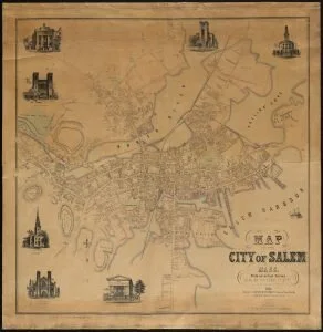
Map of the City of Salem, 1851, by Henry McIntire. c/o Boston Public Library

Map of Salem Village, 1692 by William P. Upham, 1866
c/o Boston Public Library’s Leventhal Map Center

Map of Salem and Surrounding Places, 1903 by Henry M. Meek. c/o Boston Public Library’s Leventhal Map Center

Partial map of Salem, 1905, by Sydney Perley. c/o Boston Public Library’s Leventhal Map Center

City of Salem from Walker’s Atlas of Massachusetts, 1916 by Walker Lith. and Pub. Co. c/o Boston Public Library’s Leventhal Map Center

The port of salem, 1930

Map Showing Location of Gallows Hill, according to Sydney Perley, 1921
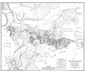
1700 Salem, by James Duncan Phillips, 1933. Based on research of Sydney Perley. Digitized map c/o the University of Virginia Library

local history districts


